




Lake Chelan, Washington: The Third Deepest Lake in America
Lake Chelan is a narrow glacial lake in Chelan County, Washington, stretching from the town of Chelan deep into the North Cascades. Only Crater Lake and Lake Tahoe are deeper in the United States, and the far end of the lake at Stehekin can only be reached by boat, floatplane, or on foot.
- Location: Chelan County, Washington, from Chelan and Manson in the southeast to Stehekin in the northwest.
- Size: About 50 miles long and roughly 33,000 acres of water, with an average width of only about 1.3 miles.
- Depth: Up to 1,486 feet deep, with an average depth of about 474 feet.
- History: A natural glacial lake, raised about 21 feet by the Lake Chelan Dam completed in 1927.
A lake that runs fifty miles into the mountains and drops nearly 1,500 feet is hard to picture on a flat map. Layered wood shows that depth at a glance.
Precision Craftsmanship by Moc Tho: Mapping Lake Chelan as a 3D Wood Map
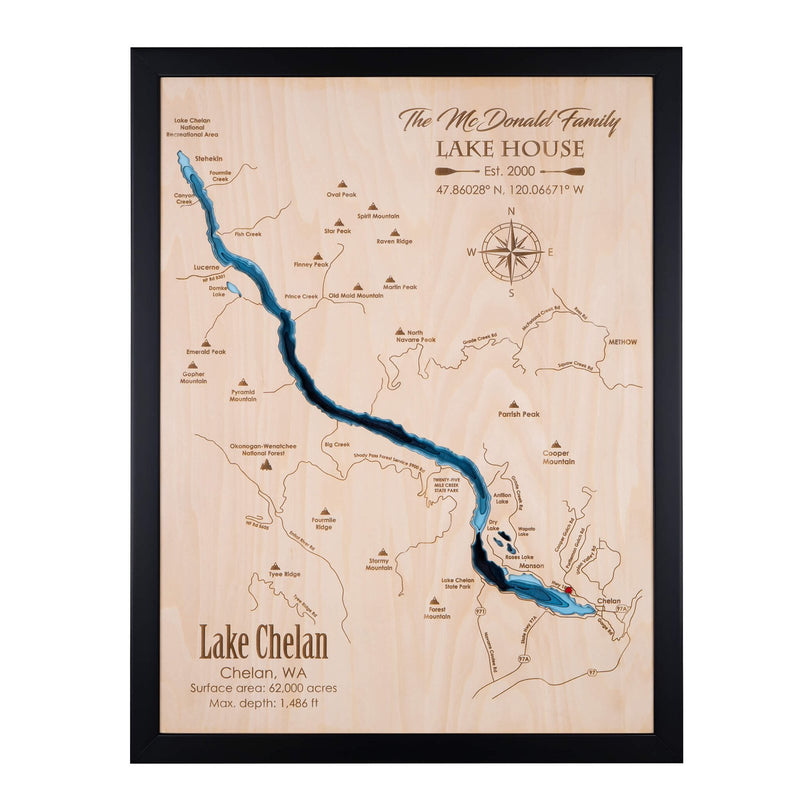
Moc Tho maps the whole of Lake Chelan, from the vineyards around Chelan and Manson to Lucerne and Stehekin at the head of the lake. The deep, narrow trough of the upper lake stands out as the darkest layers, while the shallower lower basin near town shows in lighter tones.

Close-up of a finished Lake Chelan wood map.
- Layered 3D Depth: The Lake Chelan map is built from 9 laser-cut layers of 3 mm birch, so the deepest water sits visibly lower than the shallows.
- Design Proof Before Production: Moc Tho emails a PDF design of your map before any wood is cut, and you can ask for changes until it looks right.
- Personal Details: Mark your home, dock, or favorite spot with a heart, star, or house icon, and add names, dates, or a short message.
- Made as a Gift: A gift for anyone with a cabin in Manson or Chelan, a summer tradition on the lake, or memories of the boat ride up-lake to Stehekin.
- Ready to Hang: Every map arrives framed in solid wood with hanging hardware attached.
Points of Interest on the Lake Chelan Wooden Map
The map is engraved with local landmarks such as: Chelan, Manson, Lucerne, Stehekin, Domke Lake, Lake Chelan State Park, Twenty-Five Mile Creek State Park, Lake Chelan National Recreation Area, Okanogan-Wenatchee National Forest, Antilon Lake, Wapato Lake, Roses Lake.
Moc Tho's Lake Chelan Wood Map: Where Geography Meets Craftsmanship
The Lake Chelan design follows the full length of the lake and the mountains that rise around it, from Emerald Peak and Pyramid Mountain on the west side to the ridges above Manson. Towns, roads, parks, and peaks are engraved on the top layer, and the water steps down through nine hand-stained layers to show how quickly the lake deepens.
Every Moc Tho design starts from two data sources:
- Map data for scale: shorelines, roads, and towns are traced from current map data so distances and proportions stay true to the real lake.
- Bathymetric data for depth: depth contours are converted into the stacked layers you see, from the shallow edges to the deepest channels.

How Moc Tho designs a laser-cut depth map.
Personal Touches To Make It Yours
You can engrave a family name with "Lake House" and the year your place was established, then mark the cabin with a heart or house icon. The map in the photos shows one customer's personalization as an example. Up to 5 personal details are included at no extra charge.

The layered depth effect up close.
Popular personalization choices:
- Your home address or family name with a location marker
- Wedding or anniversary date
- A short engraved gift message
- Marina, boat ramp, or favorite fishing spot
- Local landmarks
Can't Find Your Perfect Spot? No Worries!
If this Lake Chelan map is not quite the area you have in mind, Moc Tho can design a custom map of any lake, river, island, or coastline around the world.

🛒 Start Your Custom Order Now and tell us the place you want to keep.

We Are Special!
Moc Tho's 3D Wooden Maps

Captivating Detail with Laser Precision
Moc Tho uses laser cutters to etch intricate and fascinating details into up to 9-12 layers of relief. Each topographic nautical map is hand-drawn by our artists and laser-cut with unmatched precision, offering a unique piece of art that's detailed to perfection.

Accurate Representations
Our maps provide accurate depictions of surrounding towns, roads, state lines, and water depths, breathing life into this unique piece of art.

Unlimited Customization Options
Moc Tho offers unlimited customization options. Add personal icons, quotes, or landmark callouts, tag any place with different marks, or create your favorite pond, lake, or waterway. The possibilities are endless!

Rustic Appeal of Natural Woods
Moc Tho's Map Art products are crafted from beautiful natural woods like Ash, Oak, and Birch Plywood, ensuring a 100% natural and high-quality product. The rustic charm complements any Coastal, Beach, or Lake House décor seamlessly.

Ready-to-Hang
Our products come fully assembled and ready to hang, perfect for creating a collage of your favorite destinations. You can even customize our existing maps with special icons or sayings.

Bestselling Unique Gifts
Our wooden maps are more than just a beautiful piece of art. They serve as a perfect gift to commemorate a special occasion - be it a New Lake House, a Beach House, a Special Vacation, a Waterfront Wedding, or a Holiday Gathering on your favorite coast.